
Mapping A Long Run for Marathon and Ultramarathon Training
Dear A & H…Remember how I feel about gadgets? Well, considering I still have a hard time connecting my phone to free wifi, that about answers that question. Ah, it’s hard giving up old ways and leaving the 20th century. ت My approach to running looks kind of the same…no heart-rate monitor…no GPS…just me and my surroundings. But, I have to admit, sometimes a little innovation is helpful, even necessary, especially during marathon or ultramarathon training. When training for these races, it’s nice knowing if weekly long runs are well thought out and planned. But, without gadgets, how does one do this easily?
How Far Was That?
One inherent difficulty with running naked (i.e. sans gadgets) is judging distances. This is especially true with trail running. A five-mile run on single track over gently rolling hills will take considerably less time than covering that same distance over technical terrain. With technical terrain, after navigating rocks, roots and elevation changes, five miles feels much more like seven…eight…nine…
This is specifically why I don’t pay attention to distances when working out.
Not at all.
All that matters to me is time and effort. If I have an hour, I run an hour. Doesn’t matter where I go, so long as I’m putting effort into those 60 minutes.
However, there’s a time when it’s helpful knowing approximate distances and keeping track of them.
It’s when a decision is made to enter a long race, think marathon or ultramarathon.
For these distances, it’s helpful knowing if scheduled long runs are adequately planned. When well thought out, long runs become the primary instrument to condition both body and mind for the rigors of multi-hour events.
Planning a Long Run
Some things to consider:
- If a trail marathon is on the calendar 3 months in the future, are long run at least 2/3 to 3/4 of those 26.2 miles?
- If a race is 50K or longer and long runs are split over two consecutive days instead of one, are these distances of adequate length to acquaint both body and mind for race day conditions?
One simple way to accomplish planning such as this is at a site called Run My Route (RunMyRoute.com) which, as the name implies, allows runners to track their running routes. Though it’s most helpful at mapping routes over physical roads, noteworthy trails can also be accessed.
Here’s what Run My Route says about themselves:
About Us
Run My Route is a community-based running site. We are striving to provide a simple, easy to use, website for runners to track running routes. We have added in features for users who sign up such as saving your routes and your own training log to track your workouts. The best thing, it is all free!
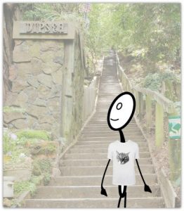
Photo: Wikimedia Commons (CC BY-SA 3.0)
Tracking a Run Using RunMyRoute.com
To show how Run My Route can track a workout over both road and trail, we’ll track Jack’s most recent long run. As luck would have it, it’s one from his bucket list.
During that particular week, Jack was in the San Francisco area attending a west coast microbiology conference. Being so close, he couldn’t help but stay an extra few days to tackle his dream trail, the Dipsea.
Both ways…
Start at Mill Valley…up 676 stairs…to Cardiac…to Steep Ravine…to Stinson…to the Pacific…turn around…then head back.
13.7 (or thereabouts) miles of bliss.
The weather was perfect that day…
Sunny…
Clear…
Though finding parking was a little challenging…

~~~~~ Was off!
Lucky guy! 🙂
Tracking Jack’s Long Run on RunMyRoute.com
Getting Down to Business
Once at Run My Route, click on “Create Running Map” under “Tools” in the footer.
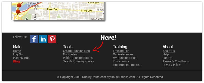
Initiating a Route Map
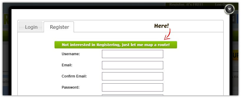
A sign-up page pops up after that click. While subscribing to this site is useful if you’d like to save routes or maintain a training log, for today’s purposes, we’ll just click on “Not interested in Registering, just let me map a route!“
Navigating
Next, at a map of San Francisco and the surrounding areas, we’ll navigate to Mill Valley, California, (north of San Francisco) and zoom in until street names are visible.
Upon finding Laurel Street and Throckmorton Avenue, the intersection at which Jack started running, a simple click here is all that’s needed to start tracking his progress. It will show up as a single red dot.
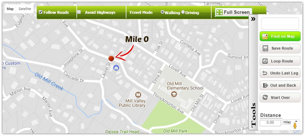
Click to Track
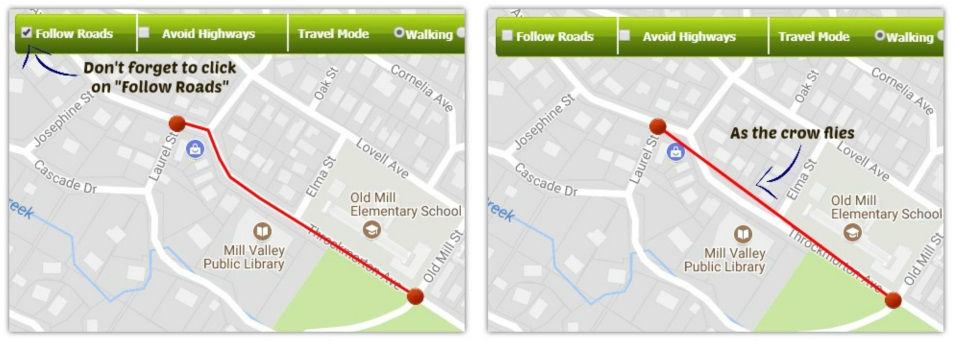
From this point on, it’s only a matter of clicking at intervals along the course Jack takes. Note: Be sure to click on “Follow Roads” at the top left-hand corner of the map before initiating this step otherwise tracking will be “as the crow flies.”
The clicking part takes the longest.
Click…click…click…
That’s Pretty Much It
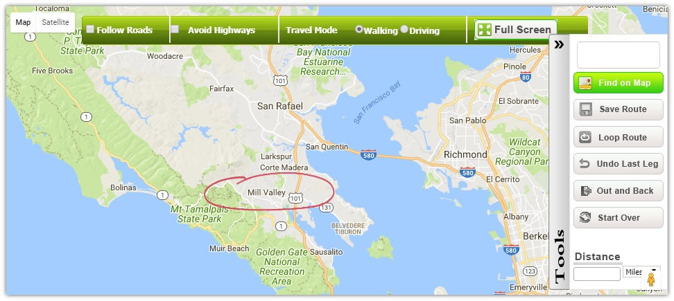
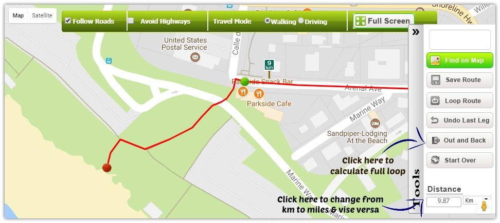
Once at the turnaround point, there’s no need to do any more clicking unless Jack takes a different route back to his car. Since he doesn’t, all we have to do is click on the “Out and Back” button within the “Tools” section (to the right of the map) and we’re done. (See photo above.)
The information about distance (miles or kilometers) we hoped to obtain by creating this running route was provided by way of signposts that popped up all along the way. Distance is also available in a small box located at the bottom of the “Tools” section. It’s here where distance can also be converted from kilometers to miles and vice versa. (See photo above.)
Note: Run My Route offers more features than those illustrated here, such as “Satellite” mode. A nice feature because nothing’s more empowering than seeing what you’re capable of doing (or did) with real pictures. 🙂
That’s It
This online tool is simple but effective for creating and tracking long runs when preparing for longer races beyond the half-marathon. Knowing you’ve covered at least 2/3 to 3/4 of a marathon over the course of one day or, in the case of ultramarathons, over the course of two consecutive days, does much to bring peace of mind when preparing for a race.
So, if you’re like me and not one for gadgets, then the few moments it takes to create a map such as the one we made for Jack will provide much reassurance that workouts are indeed preparing body and mind for the rigors of race day.
Beyond that, though, I encourage more “doing” than “recording,” especially if your schedule is tight and time’s a precious commodity. Stats are interesting, for sure, but not always helpful to everyone. I’ll explain more about this in a future post.
Finally, a nice benefit from tracking a few long runs like we just did for Jack is getting better at judging distance over varied terrain. Maybe not exact or perfect, but better as time goes by.
But, whether this skill gets improved or not, in the end, as always, what’s most important is just putting forth best effort no matter where you might find yourself on a run.
Much love, O.M.
P.S. Have you found this post helpful? If “Yes!,” please consider sharing, loving your body with a few miles today, and signing up for notice of new content. Thank you!
P.P.S. No spam ever. Staying away from processed is a healthy thing to do. 🙂